A more troubling picture of sea level rise is coming into view
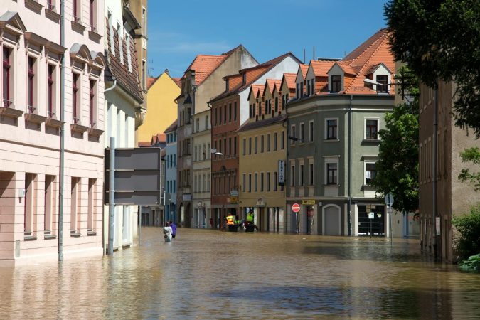
I first started thinking about coastlines differently while walking through Semarang, a coastal city on the Indonesian island of Java. I'd gone there the way I go to most places — on foot, no particular destination, just following the rhythm of the streets. But in Semarang, the streets themselves told a story I wasn't expecting. Houses stood on stilts that had been raised, then raised again. Doorways I passed bore faint watermarks well above my head. Whole neighborhoods had simply disappeared beneath the waterline, their former residents relocated to higher ground that was itself, I learned, sinking.
I've spent a decade writing about cities. How they feed people, how they move, how they reveal their values through design and daily habit. I walk cities to read them. And increasingly, what I'm reading is a story about water. Recent research has fundamentally redrawn the map of coastal risk, and the picture is worse than the one policymakers have been working from for decades. Sea levels, measured directly by tidal gauges rather than estimated through global models, may sit higher on average than some scientific literature has assumed. At the same time, satellite radar mapping of major river deltas shows the ground itself is sinking. In many cases faster than the ocean is rising.
The conventional wisdom, baked into IPCC reports and the funding decisions of bodies like the World Bank, has been that we know roughly where the waterline is and roughly when it will move. Both assumptions now look shaky. The combined effect of these findings is that tens of millions of people previously considered safe from this century's flooding may, in fact, already be living on borrowed time. And those people aren't abstractions on a map. They're the café owners, the market vendors, the families I've shared meals with in cities across Southeast Asia, North Africa, and the river deltas of South and East Asia.
The measurement problem nobody caught
Research has examined coastal locations and compared the sea levels reported in the scientific literature against actual tidal gauge readings. The mismatch appears to be systematic. Real sea levels may average nearly a foot higher in some regions than the figures derived from geoid models: the mathematical approximations of Earth's shape that assume calm, uniform oceans.
The reason the error went undetected for so long is almost embarrassingly mundane. Many local coastal studies simply copy geoid outputs rather than use measured data, even when tidal gauge records exist. Geoid models happen to be most accurate around Europe and the U.S. Eastern Seaboard, which is, not coincidentally, where most of the researchers writing those studies live.
The discrepancies are largest where ocean dynamics (currents, thermal expansion, prevailing winds pushing water against shorelines) are strongest. That means the Global South. A few regions around Antarctica and the northern Mediterranean show the opposite pattern.
Recalculated figures suggest that many millions of people already live on coastal land at or below sea level. With additional sea level rise, significantly more land area and more people would fall below the waterline than earlier projections suggested.
The ground is sinking faster than the sea is rising
Studies using satellite radar have built subsidence maps of the world's largest and most populous river deltas. Many are sinking, and in numerous cases, the rate of subsidence exceeds the rate of sea level rise, sometimes by substantial margins.
The mechanism is well understood, even if the scale wasn't. Cities pump groundwater for drinking, industry, and agriculture; the emptied subsurface compacts; the surface drops. Dams upstream compound the problem by trapping the sediment that would otherwise replenish deltas from above. You can see it in the food systems, too. Saltwater intrusion poisons farmland, street markets that once sold local produce shift to imported goods, and the whole texture of a city's food culture warps under pressure that most visitors never notice.
The numbers are staggering when rendered in concrete terms. Parts of Shanghai have dropped several feet. Bangkok has experienced significant sinking. Osaka and Tianjin have lost substantial elevation. Jakarta has subsided dramatically since 1970 and continues to drop much faster than the adjacent bay is rising, a trajectory severe enough that Indonesia announced a relocation of its capital to Borneo.
Semarang, the coastal Javan city, is sinking at rates many times the local sea level rise. Residents rebuild their homes on progressively taller stilts; overnight floods in February forced another round of evacuations. Whole neighborhoods have already disappeared. Walking those streets, or what remains of them, you understand something no satellite map can convey: the exhaustion of rebuilding the same house, in the same spot, a little higher each time.
Why the Global South bears the brunt
The geography of this risk is not accidental. The measurement error is largest where ocean dynamics are strongest, which is largely the Global South. The subsidence crisis is concentrated in deltas (the Nile, the Mekong, the Mahanadi, the Yellow, the Ganges-Brahmaputra) where dense populations, intensive agriculture, and rapid groundwater extraction converge.
The Nile Delta holds two-thirds of Egypt's farmland. Starved of sediment by the High Aswan Dam since the 1960s and hollowed out from below by irrigation pumping, parts of its coastline are retreating substantially each year, threatening the city of Alexandria and salting the water table. The Yellow River delta is sinking faster than the Yellow Sea is rising, largely because numerous dams on the main stem have choked off sediment.
I think about the cities I've lived in and loved. Tokyo, Lisbon, Los Angeles. Even in those relatively privileged places, the relationship between city and water is being renegotiated. But the stakes in the Global South are of a different magnitude entirely. Experts have noted that the impacts of sea level rise under climate change have been systematically underestimated and that devastating consequences could arrive much earlier than predicted, particularly for the people who have contributed least to the problem and have the fewest resources to adapt.
The one piece of good news
Subsidence, unlike sea level rise, responds quickly to local action. Rising oceans require global decarbonization on a timescale measured in decades. Sinking land can be stabilized within years by restricting groundwater withdrawal. Tokyo provides the proof of concept: parts of the city dropped substantially in the 20th century before strict pumping regulations brought subsidence to a near-halt. I lived in Tokyo for two years in my early twenties, and you would never know, walking its streets today, that entire districts once sank beneath their own thirst for water. The city read as solidity itself. All that density and efficiency concealing a history of collapse arrested just in time.
The catch is that the cities most at risk are typically the ones most dependent on groundwater for basic services. Telling Jakarta, Ho Chi Minh City, or the Nile Delta to stop pumping requires building alternative water infrastructure first, an expensive, politically difficult proposition in places where public budgets are already stretched.
It also requires governments to act on new data rather than old assumptions. That transition is not automatic. Coastal protection schemes in Java have been restoring mangroves to buffer rising tides, only to find the groundwater pumping next door rendering the work less effective than planned. Adaptation designed around wrong baselines is adaptation that underperforms.
What happens next
The immediate implication is that thousands of local flood-risk assessments, coastal planning documents, and international climate adaptation funds may be working with data that is off by significant margins. Re-running those assessments against measured tidal gauge data rather than geoid approximations is not a minor correction. It's a structural revision of how vulnerable coastlines are mapped.
For the megacities already sinking faster than the sea is rising, the policy question narrows to whether aquifer management can be reformed quickly enough to matter. For coastlines in the Global South where actual sea levels may be higher than modeled, the question is whether funders will accept shorter protection timelines and higher price tags.
Here is what nobody wants to say out loud: the timelines we have been planning around are fictional. Seawalls take a decade to build. Aquifer reform takes longer. Capital relocations take a generation. Meanwhile the ground in Jakarta, Semarang, Alexandria, and the Mekong is dropping on a schedule that does not care about our procurement cycles or our political ones. What happens when the sinking outruns the seawall? When the new capital isn't ready and the old one is already underwater? When the food systems I've spent a decade documenting in market after market simply cease to function because the farmland behind them has gone saline?
We are not facing a coastal problem that arrives later this century. We are facing a coastal problem that has already arrived, mismeasured, in cities full of people who were told they had time. The honest question is no longer how we protect every threatened coastline. It is which ones we admit we cannot, and how soon we tell the people living there. Adaptation built on wrong baselines is not adaptation. It is delay. And delay, on this schedule, is a decision about who drowns.