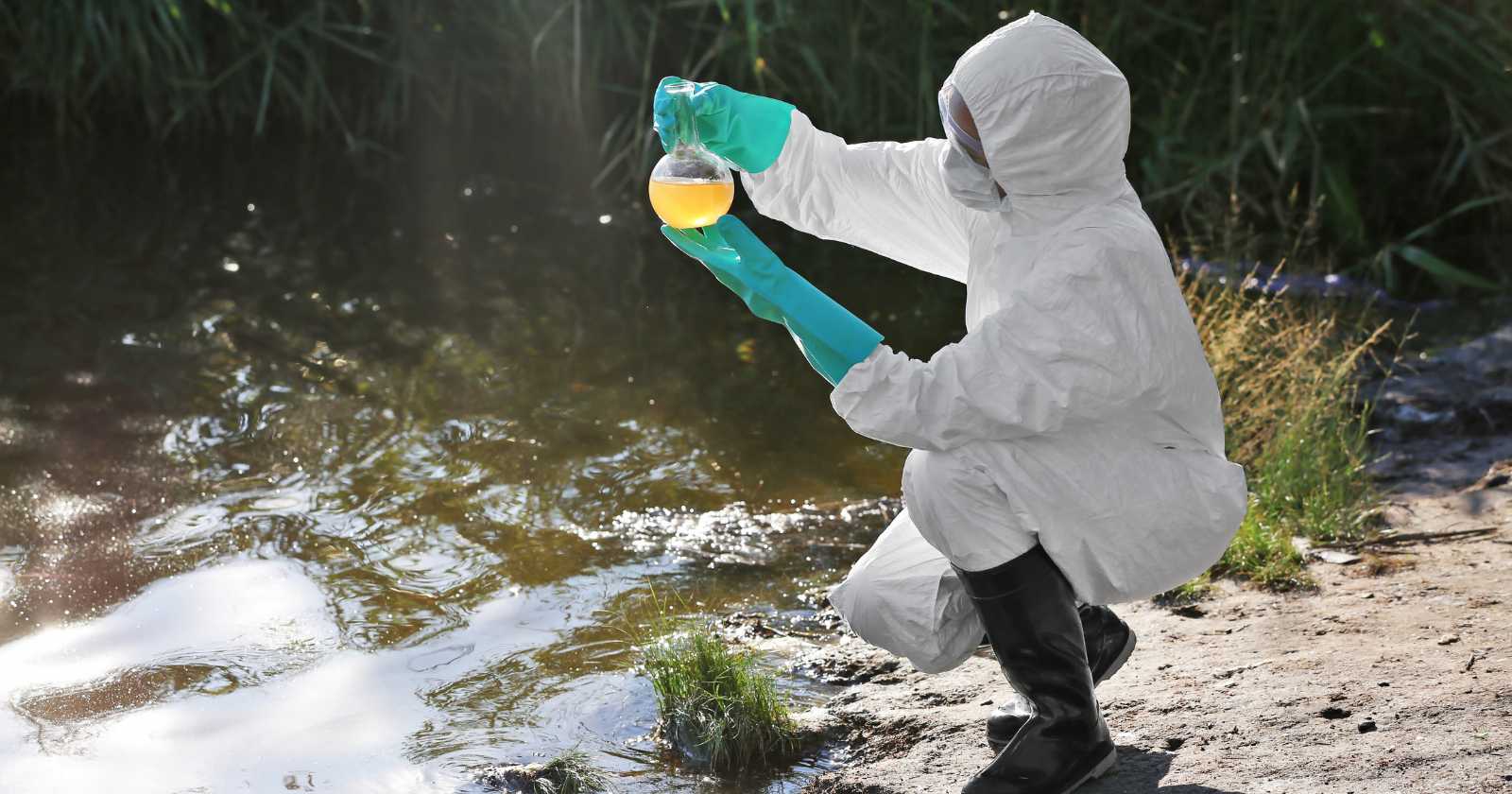
Six months after jet fuel began leaking from Joint Base Andrews into the headwaters of Piscataway Creek, the people most likely to come into contact with the contamination — anglers, boaters, and shoreline residents at Fort Washington Park — still do not have official water quality data from federal agencies. So Indigenous stewards and a regional river conservation group have stepped in to do the testing themselves.
The standard assumption around environmental disasters is that federal and state agencies, armed with permits and enforcement power, will track contamination wherever it travels. The Piscataway Creek case complicates that assumption. The base has confirmed it has no plans to sample at the tidal mouth of the creek where it joins the Potomac, the National Park Service has not communicated with state regulators about downstream impacts, and the Maryland Department of the Environment only extended its monitoring after residents asked for it in person.
What spilled, and what stayed in the water
According to Inside Climate News, the leak at Joint Base Andrews in Prince George's County was detected on December 11. An estimated 32,000 gallons of jet fuel spilled into the headwaters of Piscataway Creek. Only 10,000 gallons were recovered. The remaining 22,000 gallons entered the environment.
The base waited more than three months before notifying state regulators. By late March, the alert was triggered by odors and a fuel sheen near the headwaters — not by the base's own reporting. A statement from Maryland's Department of the Environment noted that the leak detection system at the base failed multiple times between January and March, and a containment dam later collapsed during heavy rain in early April. The full extent of the discharge was not reported until April 8.
"While Maryland values its deep ties to federal defense installations across the state, contaminating Maryland's land and water is unacceptable," Maryland Secretary of the Environment Serena McIlwain said in the agency statement. MDE has since ordered the base to clean up the site and isolate the failed portion of the fueling system.
The 18.6 miles the agencies haven't tested
From its headwaters near the base, Piscataway Creek runs 18.6 miles before emptying into the Potomac at Fort Washington Park. That access point, along the shoreline of the adjacent Piscataway Park, is one of the few public fishing piers on that stretch of the river. It draws anglers from across the Washington region. The land around it is managed by the National Park Service.
None of that downstream area has been sampled by the base. "We have not conducted water sampling in those specific locations," Matt Ebarb, Joint Base Andrews' media operations chief, told Inside Climate News in emailed comments. He added that the base had completed joint sampling with MDE in April and May at sites on and just off the installation, and that contamination levels were decreasing over time.
Asked whether the base would extend testing to the tidal mouth, Ebarb said it would not. "The base does not intend to conduct assessments at the tidal mouth of the creek," he said, adding that testing on and immediately surrounding the installation already provides relevant data.
The National Park Service, whose parent Interior Department was notified of the leak in late March, has not contacted Maryland regulators about the issue. MDE spokesperson Jay Apperson said the agency would coordinate with NPS if asked, but the outreach had not come. Interior and NPS did not respond to multiple requests for comment from Inside Climate News.
Community groups filling the gap
The Accokeek Foundation, which manages Piscataway Park under a longstanding agreement with NPS, has partnered with the Potomac Riverkeeper Network to launch independent water quality monitoring at the park. Trained volunteers will collect weekly water samples, which will be analyzed through Potomac Riverkeeper's community science program and the Sea Dog floating laboratory at National Harbor.
Anjela Barnes, the foundation's executive director and a member of the Piscataway people, framed the goal in practical terms: the foundation aims to provide residents, anglers, visitors and park stakeholders with information about local water quality.
The foundation has also posted advisory notices at the public fishing pier and visitor center. That guidance lands on top of pre-existing fish consumption advisories from MDE — bass from the tidal headwaters and sunfish from the non-tidal section of the creek were already flagged for PFOS contamination before the spill. The advice now compounds: avoid recreating where you see sheen or smell fuel, and be careful about what you eat from a waterway that was already carrying chemical baggage.
A 400-year argument about cumulative harm
Barnes pushed back on framing the jet fuel leak as an isolated event. She argued that cumulative environmental impacts in the area stretch back more than 400 years, and that the environmental history of the Piscataway homeland should be understood as interconnected rather than as a series of isolated incidents.
She traced a chain stretching from the collapse of beaver populations during the 17th-century fur trade, through forest clearing for plantation agriculture, shoreline alteration, industrialization, overfishing, stormwater runoff, wastewater failures, PFAS contamination, and now the jet fuel release — chapters, she said, in a much longer story of cumulative ecological change. For Indigenous communities along the creek, she added, waterways are understood as part of an interconnected cultural landscape, not just environmental resources to be measured.
That framing matters because it changes the question being asked. Regulators are calculating whether a specific plume of jet fuel exceeds a specific threshold in a specific stretch of water. The community is asking what it means for a waterway to absorb one more insult after centuries of them.
The accountability question
Citizen science has become a more visible part of environmental monitoring over the past decade. Trained volunteers using passive samplers can detect contaminants of emerging concern in freshwater systems, often filling data gaps that agencies leave open. The model works. It also raises a hard question: should it have to?
Barnes was clear on where she thought the line sits. She said that while the foundation can help bridge relationships with communities, ultimate responsibility for monitoring, enforcement, remediation and notification lies with the official agencies.
The pattern in Piscataway Creek is one VegOut has touched on before in a different register — the way ordinary people end up building the infrastructure of kindness when institutions fail to show up. It is generous work. It is also work that gets folded into a structure where the polluter, the regulator, and the federal land manager can each point at the others while a community runs the boat and collects the samples.
What happens next
MDE expected to begin downstream sampling within roughly two weeks of the May 9 community meeting, with results returning 10 to 14 days after collection and posted to a dedicated page on the agency's website. The base says contamination levels at the upstream sites are declining. The Accokeek Foundation and Potomac Riverkeeper Network plan to keep sampling weekly.
What the Piscataway Creek case reveals is less about one fuel leak and more about who carries the weight when oversight stops at a property line. The 22,000 gallons that escaped recovery did not stop at the boundary of Joint Base Andrews. The accountability for finding out where they went, apparently, did.